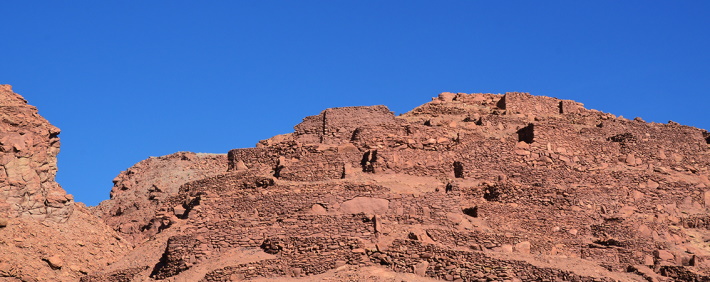
The main purpose of the Pukara de Quitor, in addition to living, was fortification for defense purposes against possible sieges of war. This factor conditioned everything from the choice of the site to the character of the buildings and the internal roads.
The topographical position chosen to build the pukara was excellent from a strategic point of view, considering that it is located on the southern slope of the ravine through which the San Pedro River flows. The erosion that affected this hillside originated steep rock outcroppings on the north and west sides; to the south, an abrupt ravine frames the inaccessibility of the terrain; the east side allows access by a relatively regular slope, but with an average sharpness of 30° angle of inclination.
The maximum height of the hill from the river bed reaches 80 m.
The space in which the buildings are distributed covers about 24,000 m2 with extreme lengths of 200 m long by 120 m wide. In the access by the east side (the most vulnerable) there is a colossal defense wall arranged in a serpentine and broken way, practically covering the width of the pukara in an approximate length of 121 m. Its thickness is 1.20 m (average) and its variable height reaches up to 3 m on the outside. The only possible entrance detected so far to cross this wall are two ladders that are part of it, which are well concealed and allow highly controlled access.
Inside, the first constructions stand out due to their size and shape, which maintain a certain orthogonality. This is due to the fact that in the first part the slope is less acute, which allowed an easy adaptation to the terrain, in the upper levels the compensation and containment works were essential before building. As we ascend we can see three depressions in the hill that can be called quebradillas, in them we find a type of structure that adapts to this accident, presenting a wedge effect against the hill, achieved by a straight wall at the front and another in a curved shape that complete the perimeter.
The rest of the constructions take various forms depending on the terrain, which defines true "neighborhoods" according to their location in the relief and the needs of circulation. These conditioning factors increase the predominance of curved and mixed forms in the floors where corner angles and circular walls tenaciously combine. In a general operation, a greater frequency of the semicircle can be concluded in the structures, arranged in an irregular but quite effective terracing that could resemble the stands of a colossal amphitheater.
THE ATACAMEÑOS
The Atacameños are a people of cattle, agricultural and warrior people who defended their territories with courage and strength. It was in the Pukará de Quitor where they organized themselves for their resistance against the European invader. There they found a people raised in war that, despite their suffered defeats, managed to resist for more than 20 years. In 1557 a peace agreement was established that meant the surrender of the Atacameños, marking the beginning of a process of acculturation of the ethnic group, since it did not resist the strong impact of the imposed Hispanization. They were baptized with Christian names and changed even the Ayllus. As of the 17th century, the administrative power of the corregidores is strengthened and in parallel -paradoxically- the organization of the old Ayllus is recovered given the proven efficiency.
The housing pattern, in general, consists of uni-spatial structures that in some cases are divided into two. In most of them a smaller structure is included, probably used as a silo. We note that there is very little similarity in the shape of the various structures. A large semicircular construction stands out in the center of the pucara, which has been called a “turret” due to its slight resemblance to this element of medieval European castles. This “turret”, which was probably the main lookout post, impresses with its excellent location with visibility of up to 80 km. On the top of the hill are isolated and rectangular structures. One of them is large, which suggests a different period and function from the rest of the constructions.
The height of the walls is quite variable. The evidence allows us to assert that these are equivalent to the size of the enclosures. The masonry technique used favored a wide development of heights, in addition the terracing layout and the use of rear walls as containment of compensated land contributed to founding these walls in height. On the upper levels, the curved solution of the meeting of the walls helped to structure the high walls.
The greatest height found reaches 3.30 m if it is considered that the rear wall of the structures on the lower level was used as a base. The maximum height inside the room measured 2.20 m, evidenced by holes in the wall that suggest roof beams.
INCA EMPIRE
The Inca people were made up of many peoples with a long cultural and linguistic tradition. The Incas managed to control the governments of the Atacameño lords in the last period of pre-Hispanic development. There were clashes with refugee groups in the Pukaras of Lasana and Quitor for control of the valleys and oases. Apparently, in a state of peaceful coexistence with the Atacameños, the Inca occupation seemed to sustain itself, thus establishing administrative centers and garrisons. In 1536 in San Pedro de Atacama there was already news that the Inca empire had been conquered by the Spanish and profound economic, political and social changes produced by the clash of two different worlds began.
The construction technique is remarkably successful, the result of a favorable combination of factors. The hill where the pukara is located is mainly made up of a kind of grayish-white gneiss in a state of decomposition. This rock was suitable for construction purposes and was found in large quantities in the same place, its extraction and breaking is relatively easy.
Clay mortar was used as mortar, which was extracted from the slopes of the river, near the pukara. The quality of the mortar, in this case, is due exclusively to the degree of salinity of the clay, which gives it exceptional cohesion and hardening power (without the need to mix it with other elements). However, this quality would not be such in an environment that does not meet conditions of extreme dryness as it is in the Atacameño desert. The salts that mainly make up these saline clays are sodium chloride and borax.
Masonries are quite heterogeneous. There are different qualities in terms of the foundation technique, lock of castellation courses and the use of glue mortar. In many cases, the use of this last element is quite moderate due to the difficult transportation through the steep slopes of the pukara hill. Despite the above, it can be described as a good development of the technique. The size of the stone was chosen in each situation and the direction of placement, in the rows there is alternation of the lock horizontally and vertically, in the containment bases there are true "pillars" that consist of the vertical placement of a large stone with an elongated shape that practically imprisons the wall to the ground. The stones used in the construction of the walls do not show signs of having been cut, there is only evidence of extraction, cutting, selection and proper placement of the resulting form.
The door openings were solved by placing long stones as jambs. No lintels were identified among the ruins, which suggests that they were made of wood, and these are reused immediately after abandonment. However, Latcham (1938) claims to have seen two stone lintels during his visit to the pucara. Although the roofs have disappeared in their entirety, we can assume that they were made from unprocessed timber from existing trees in the oasis (carob, tamarugo), used as beams, covered with branches, wild straw and mud.
The Pukara de Quitor, with approximately 164 built structures, can be considered to have achieved good adaptation and coherence with its landscape, as well as effectiveness for inhabiting and defending.
It is necessary to highlight that among the architectural expressions of the Atacameños, the pukaras are the greatest exponents. In them, the plastic sense of the volumes together with the functionality is already manifested, with the desire to appear different from the works that preceded them. The time of the pukaras is also characterized by being the culmination of the construction technologies that have evolved in the area since ancient times.
SPANISH COLONY
With the territorial domination of the Spaniards, the imposition of the new system of government and a process of acculturation of the Atacameño ethnic group began. In 1536 and 1540 the expeditions of Diego de Almagro, Pedro de Valdivia and Francisco de Aguirre, had the purpose of dismantling the political power of the Atacameño lords, producing fierce clashes between Atacameños and Spanish soldiers supported by the Yacanes Indians, who broke the defensive wall to ascend to the summit of Pukará de Quitor. With control of the fort, they decapitated the main Atacameño warriors. Since then, the Pukará de Quitor has been known as "The Town of the Heads". Then it was ordered to build the church and the government house for administrative functions and evangelization of the Atacama lands.